 Backstory Report
WaterCase File 004
Why the Mississippi Wants a New Path to the Sea
The Atchafalaya offers the Mississippi a route to the Gulf less than half as long. Gates have held it back since 1962.
What the record shows
- The Atchafalaya's share of the Mississippi's flow grew from 5 to 25 per cent between 1900 and 1950 (Fisk 1952, para. 49).
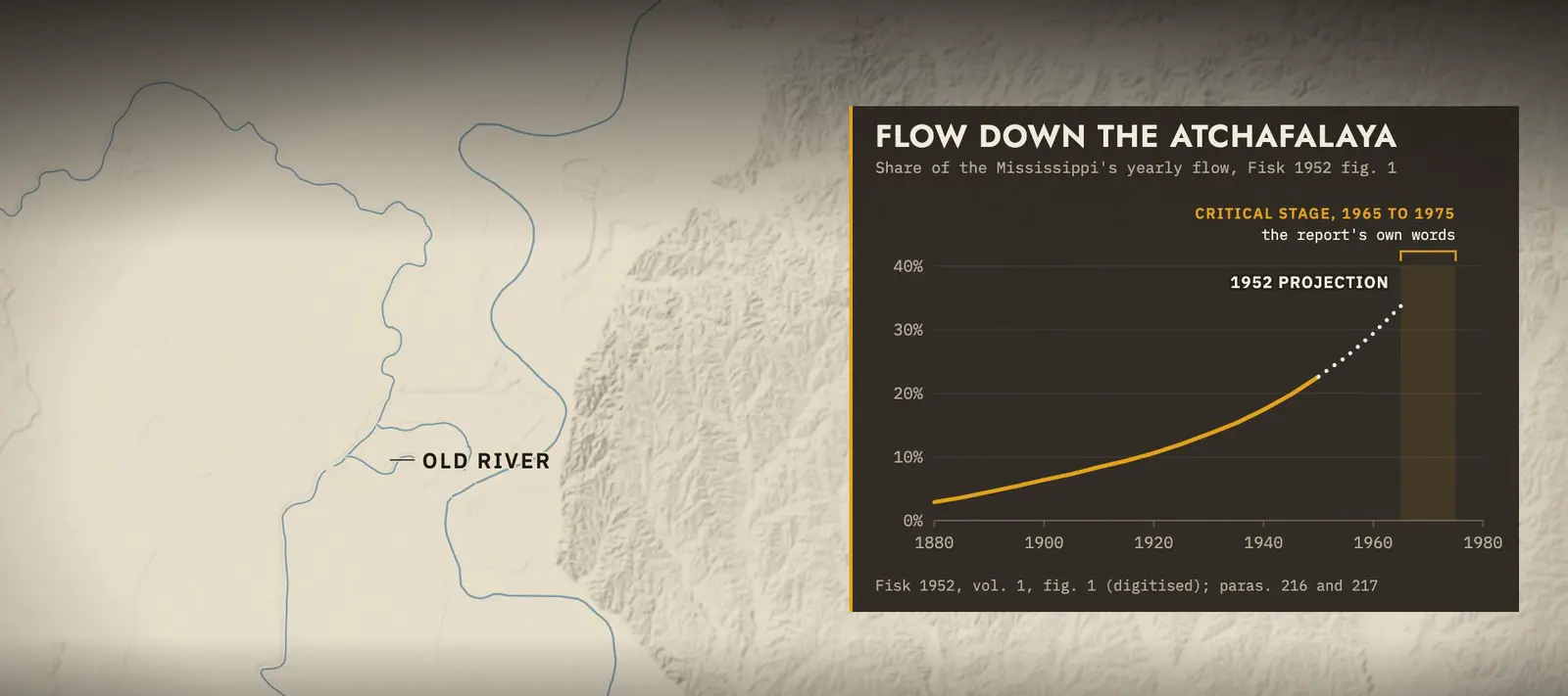
- Fisk warned the diversion would become uncontrollable before half the flow went that way (paras. 216 to 217).
- Since 1962 the Old River structures have held the split near the 1950 share, about 30 per cent (Corps 2009, p. 8).
The film

13 min. The film goes up on the Backstory Report channel; its full narration is the story below.
Two ways to the Gulf, one less than half as long
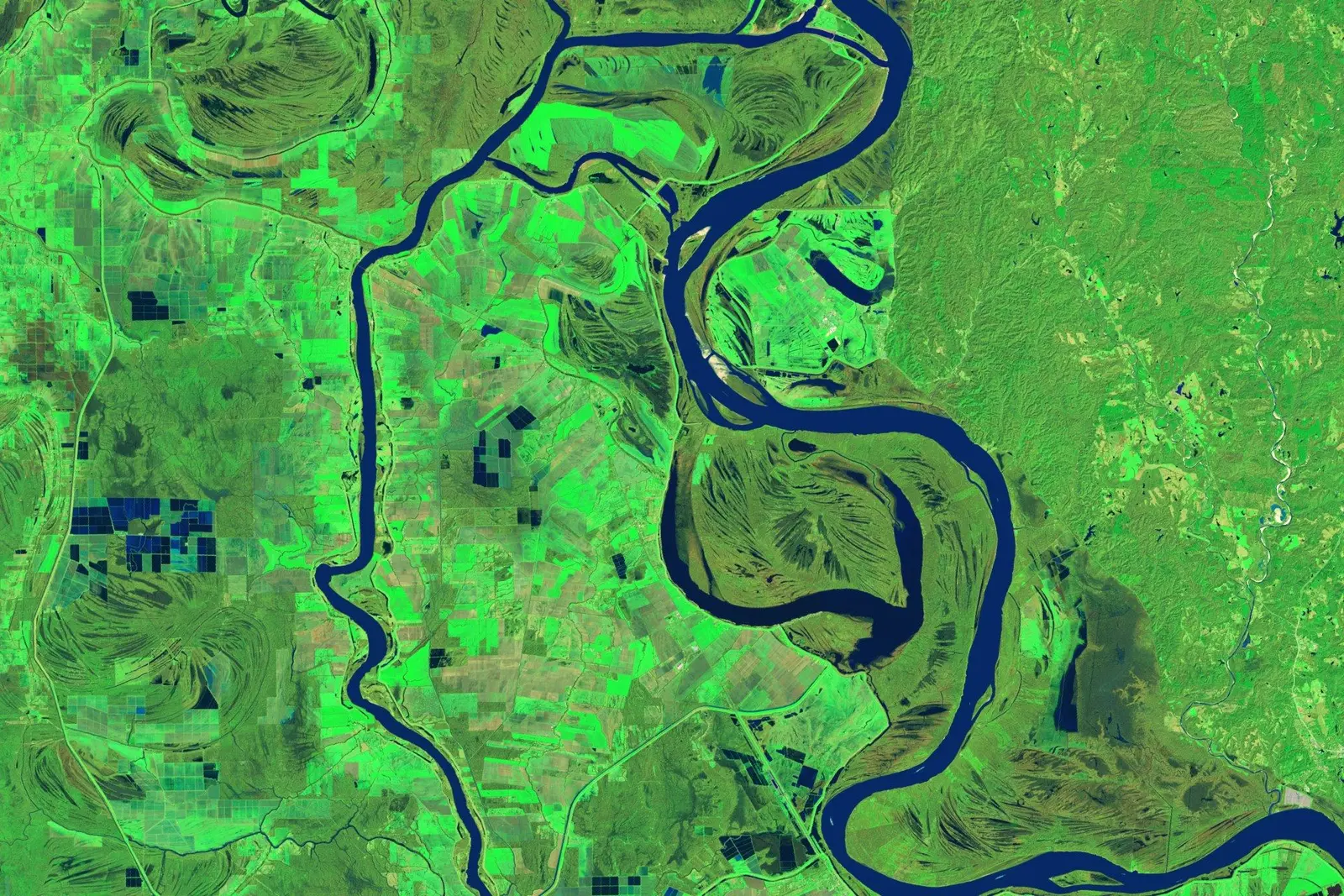
Fifty miles northwest of Baton Rouge, a short channel called Old River connects the Mississippi to the Red and the Atchafalaya. From here, there are two ways to the Gulf of Mexico. Down the Mississippi, past Baton Rouge and New Orleans: three hundred and fifteen miles, about five hundred kilometres. Down the Atchafalaya: one hundred and forty two miles, about two hundred and thirty kilometres.
Less than half the distance, to the same sea. Since nineteen sixty two, a set of gates near this spot has decided how much of the river may take the short way.
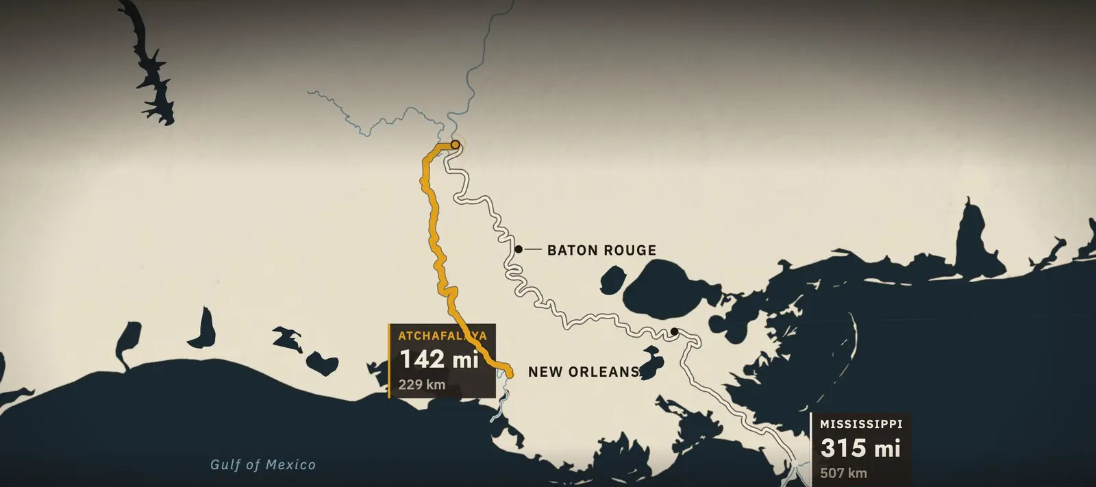
Follow the water from Old River. Which way is shorter?
Lengths: US Army Corps of Engineers, Old River Control, 2009, p. 5
The river has built six deltas in about 7,000 years
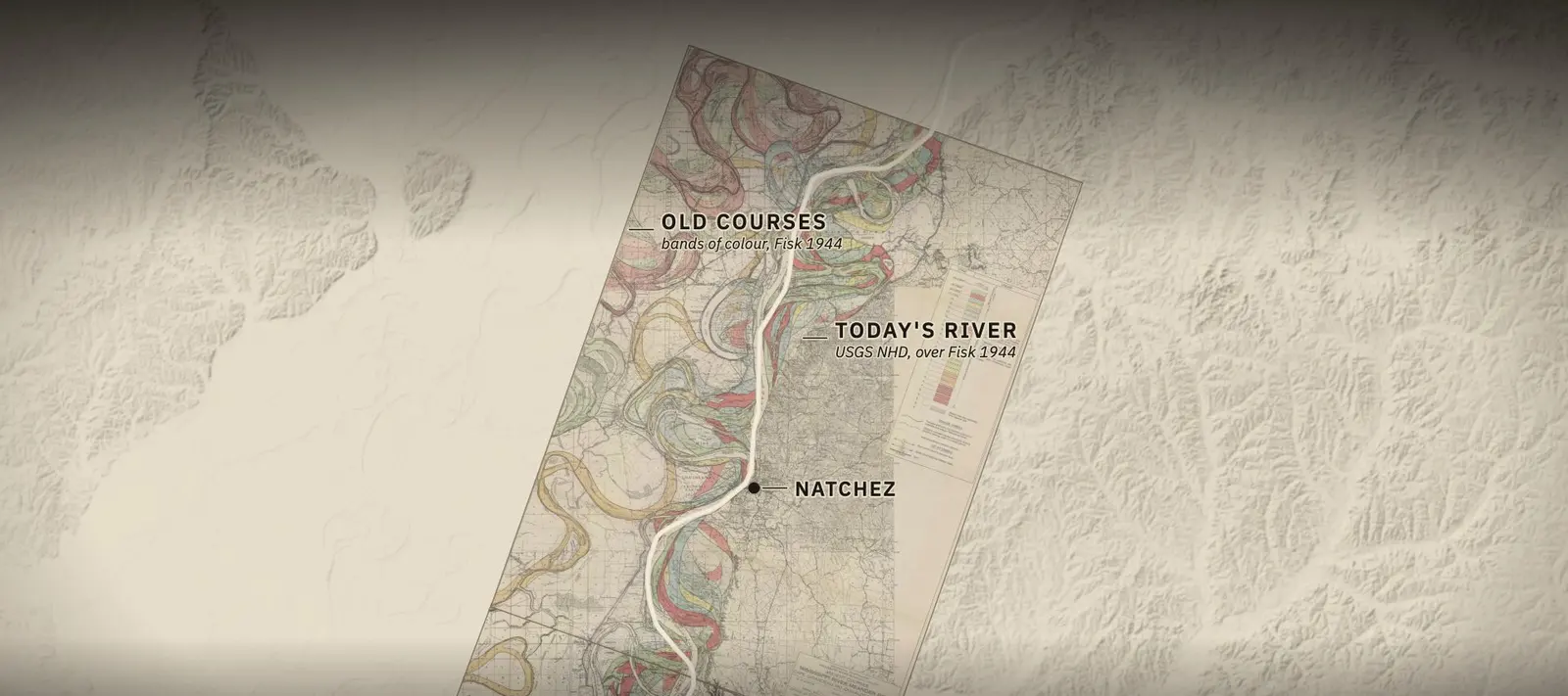
In nineteen forty four, the geologist Harold Fisk finished a study of the lower Mississippi valley for the Mississippi River Commission. One of its plates traces the river's old channels, in fifteen sheets, from Cape Girardeau, Missouri, to Donaldsonville, Louisiana.
“The Atchafalaya offered the Mississippi a shorter outlet to the Gulf of Mexico”
Corps 2009, p. 5
Each band of colour is a course the river once held. A river like this swings its bends across the valley. Now and then, in a flood, it cuts across the neck of a loop and starts a new one. Fisk traced these old courses on aerial photographs, and checked them against borings. The channels are still there, written into the ground.
Near the sea, the moves are larger. Over about seven thousand years, the river has built a delta in one place, shifted, and built another. Each time, it laid down sand, silt and clay where it met the sea. The U.S. Geological Survey groups the Louisiana coast into six delta complexes.
The oldest, the Maringouin, was built from about seven and a half thousand to five thousand years ago. Then the Teche. Then the St. Bernard. Then the Lafourche. The present delta, the Plaquemines and Balize, the one shaped like a bird's foot, began about thirteen hundred years ago.
The newest is still forming, at the mouth of the Atchafalaya. When the river leaves a delta, the land it built stops growing. It settles, and the sea wears at its edges. Geologists call this the delta cycle.
Shreve's cut made Old River in 1831
Around the fifteenth century, a loop of the Mississippi swung west and broke into the valley of the Red River. It captured the Red. The loop also cut into a small stream that ran south, out of the Red. That stream became the Atchafalaya.
When European settlers arrived, the Red emptied into the Mississippi at a loop later called Turnbull's Bend. And the Atchafalaya flowed out of the same bend, a few miles to the south.
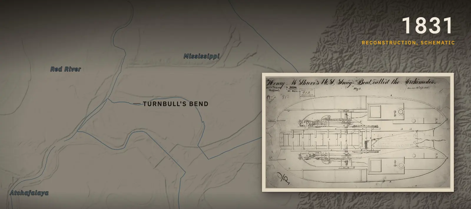
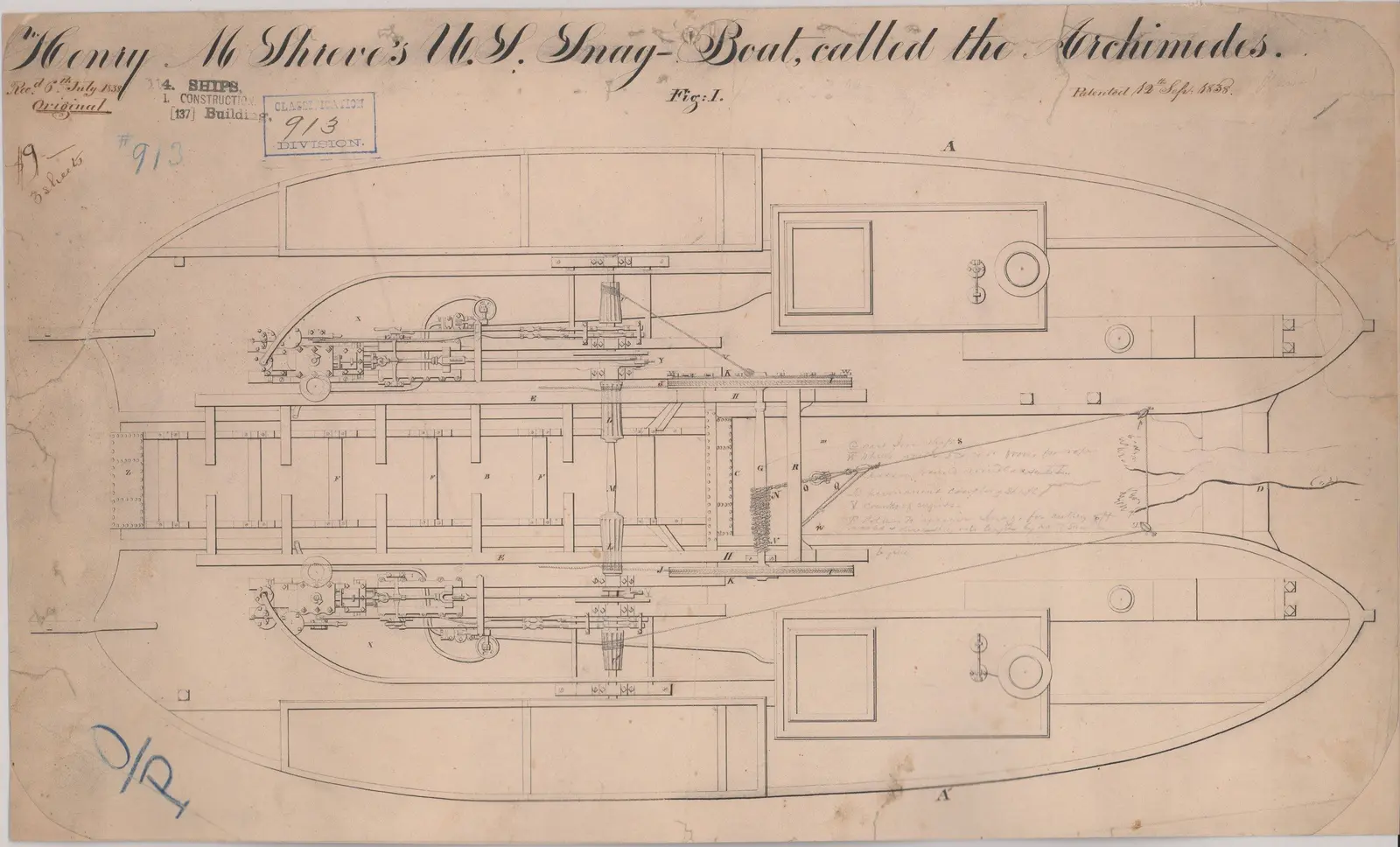
In eighteen thirty one, the steamboat captain Henry Shreve dug a cut across the narrow neck of the bend. The river took the shortcut and left the loop. The upper arm of the old loop silted up. The lower arm stayed open, and came to be called Old River.
Now the Red flowed into the Atchafalaya, and Old River joined them both to the Mississippi. Most of the time, water ran west, from the Mississippi through Old River, into the Atchafalaya. When the Red ran high, the flow sometimes reversed.
But the Atchafalaya was choked. A raft of drifted logs blocked its upper end, twenty to thirty miles long by the Corps' own accounts. In eighteen thirty nine, clearing began. People on the river set fire to it in a drought, and the state of Louisiana followed with snagboats. By the middle of the eighteen fifties, the last of it was gone.
A report of the Mississippi River Commission in eighteen eighty one described what followed. As soon as the jam was removed, the channel began to enlarge rapidly. Its bed deepened, and its banks caved.
The Atchafalaya's share grew to 1950
A deeper Atchafalaya carried more water, and the Corps measured how much. In nineteen hundred, about five percent of the Mississippi's yearly flow went down it. By about nineteen fifty, some twenty five percent.
“Discharge through the distributary has increased, since 1900, from 5 per cent to 25 per cent of the total annual flow of the Mississippi”
Fisk 1952, para. 49
Count the Red River's water too, and the Atchafalaya's share of everything passing Old River rose from fifteen to thirty percent.
The reason is in the map. Water at Old River has to fall to sea level either way. Down the Mississippi, the fall is spread over three hundred and fifteen miles. Down the Atchafalaya, over one hundred and forty two. The same drop over less than half the distance makes the short route, on average, more than twice as steep. In nineteen fifty two, a Corps report called it a sizeable advantage in gradient.
That report, written for the Mississippi River Commission under Fisk's supervision, projected the trend forward. It concluded that the diversion would reach a critical stage between nineteen sixty five and nineteen seventy five, and that after that point it would be uncontrollable. In two thousand nine, the Corps summed up that moment. By nineteen fifty one, it was apparent that unless something was done soon, the Mississippi would take the course of the Atchafalaya.
Congress authorized the control structures in 1954
In nineteen fifty three, the Mississippi River Commission recommended a complex of control structures at Old River. On the third of September, nineteen fifty four, Congress authorized the Old River Control Project.
The plan was to hold the split where it had stood in nineteen fifty. The rule: about thirty percent of the combined flow of the Mississippi and the Red goes down the Atchafalaya, measured over a year. About seventy percent stays in the Mississippi.
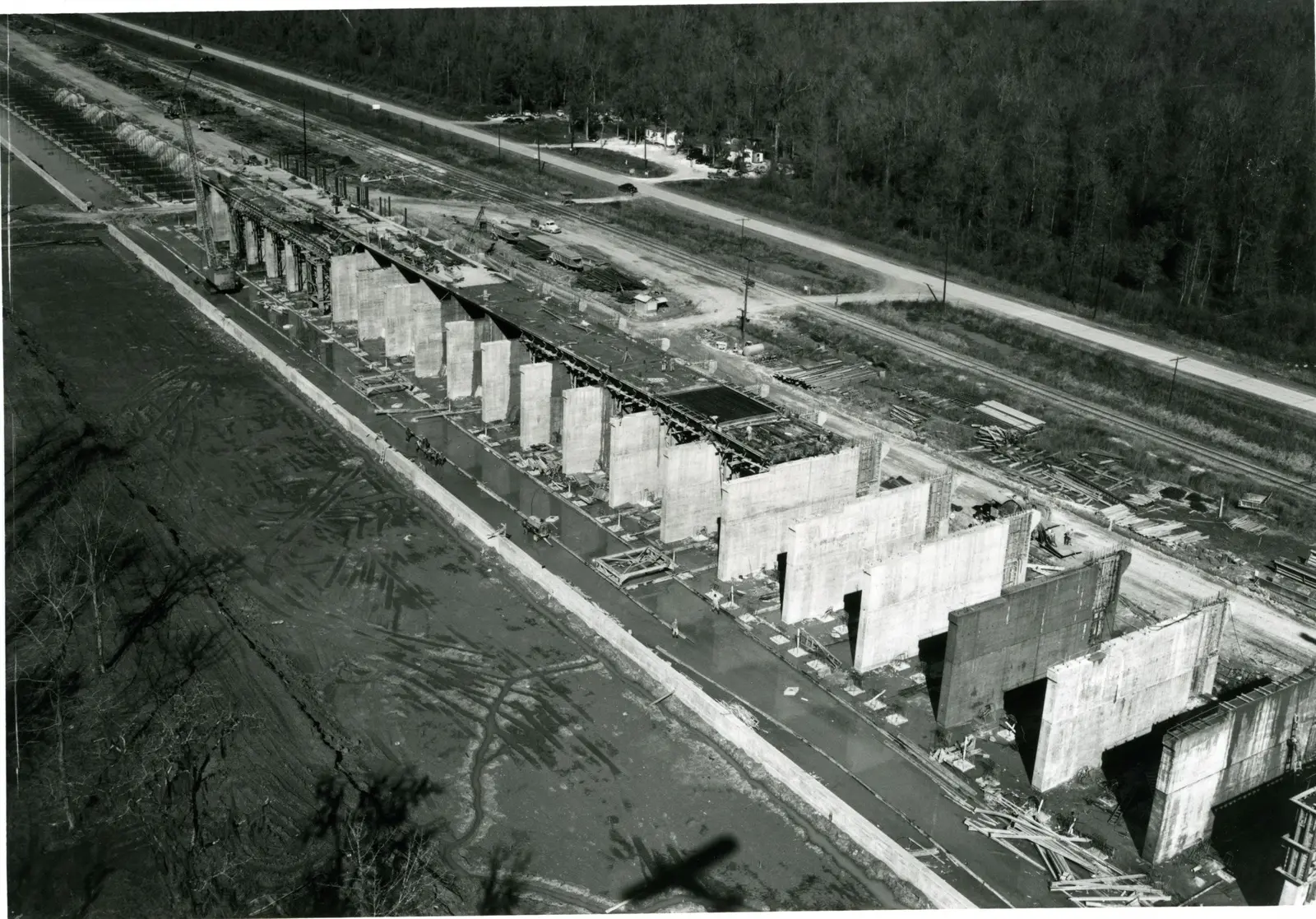
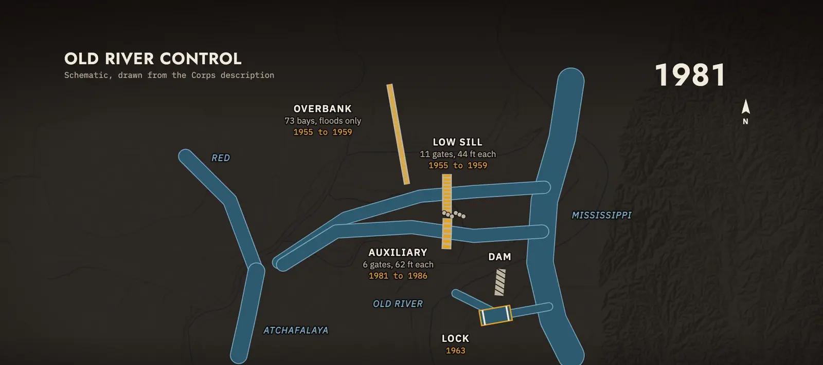
Construction began in nineteen fifty five. Old River was dammed. Two control structures went up. The Low Sill Structure, eleven gates, each forty four feet, or thirteen metres, wide, to pass water at all river levels. And the Overbank Structure, seventy three bays, for floods only. They began operating in nineteen sixty two. A navigation lock followed in nineteen sixty three.
The Corps also planned for floods larger than the river below could carry. In the plan as it stood in nineteen fifty two, the design flood was three million cubic feet per second, about eighty five thousand cubic metres a second. Half of it would leave the Mississippi near Old River, down the Atchafalaya and two floodways beside it. One of those, the Morganza Floodway, was finished in nineteen fifty four, with one hundred and twenty five gates.
The 1973 flood undermined the Low Sill
The test came in nineteen seventy three. Heavy rain through the autumn of nineteen seventy two and into the spring pushed the Mississippi's tributaries above flood stage. The river crested several times that spring. The Low Sill Structure took the brunt.
“On September 3, 1954, Congress authorized the Old River Control Project.”
Corps 2009, p. 8
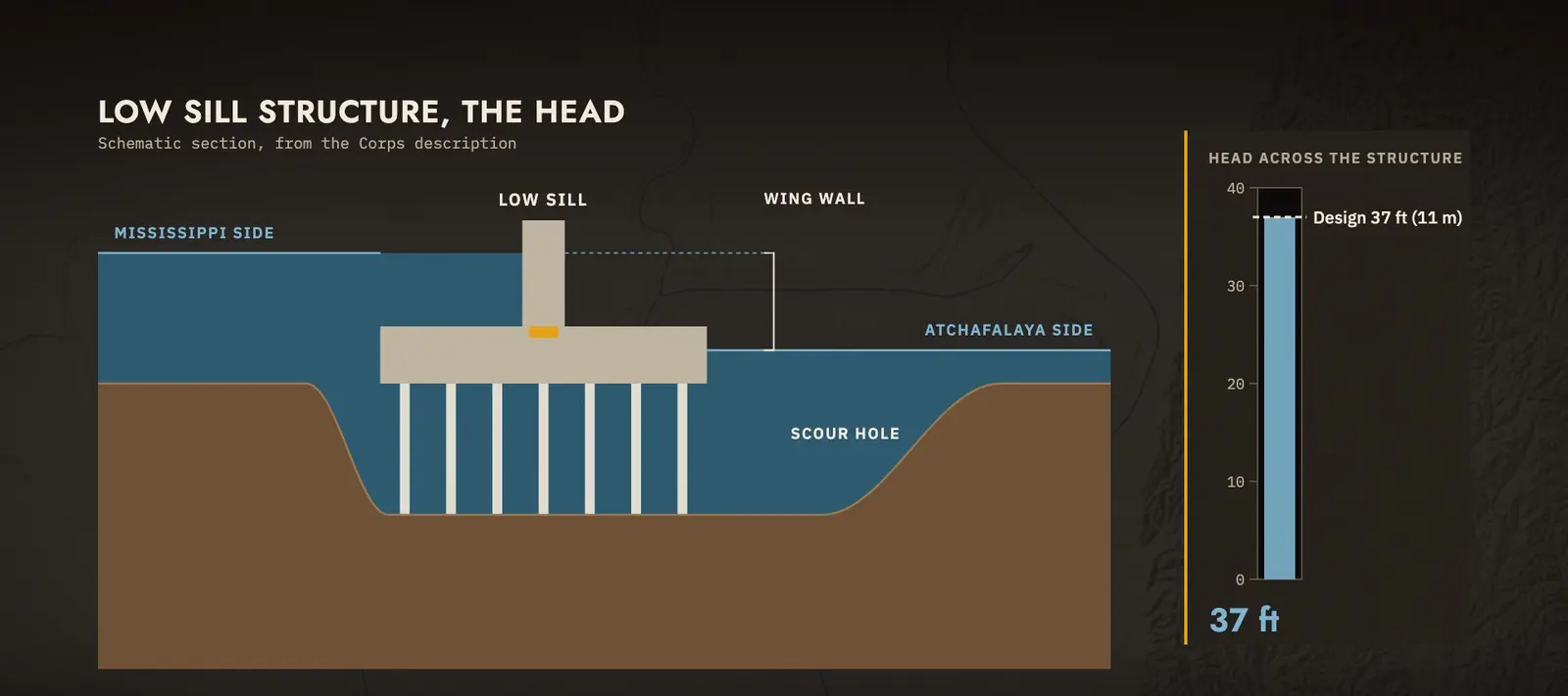
The water's turbulence scoured the foundation. It brought down a concrete wing wall, sixty seven feet high, about twenty metres, on the south end. A scour hole opened in front of and beneath the structure. About fifty feet of its ninety foot steel piles were left exposed.
Emergency work during the flood kept the structure from collapsing. The Morganza Floodway was opened in part, to take pressure off the Low Sill. Afterwards, the fallen wall was replaced with a rock dike, and grout was pumped into the void beneath.
The structure had been designed to hold a difference of thirty seven feet between the water on either side, about eleven metres. After nineteen seventy three, engineers set the safe limit at twenty two feet, under seven metres. In two thousand nine, the Corps put the working difference at four to nineteen feet, depending on the levels of the three rivers. Repairs to the damaged structures ran until nineteen eighty one.
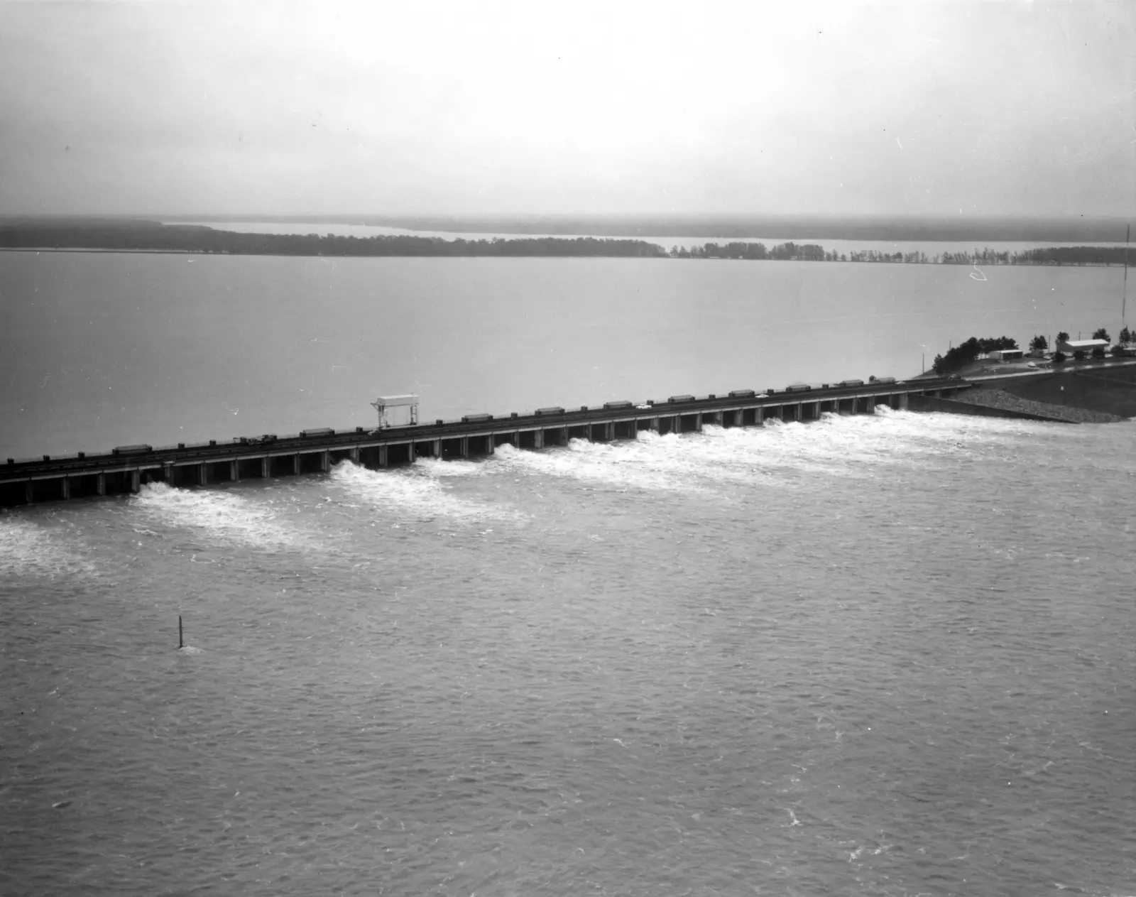
A third structure was finished in 1986
So the Corps built a third structure, on its own new channel from the Mississippi. The Auxiliary Structure has six gates, each sixty two feet wide. Work began in July nineteen eighty one. It was completed in December nineteen eighty six.
Since then, the Auxiliary and Low Sill structures have shared the work of holding the seventy to thirty split. Together, the structures at Old River can pass about seven hundred thousand cubic feet per second, close to twenty thousand cubic metres a second.
Morganza opened again in 2011
In May twenty eleven, the Mississippi at Vicksburg carried two million, three hundred and ten thousand cubic feet per second, about sixty five thousand cubic metres a second. It was the highest flow on record there, above the flood of nineteen twenty seven.
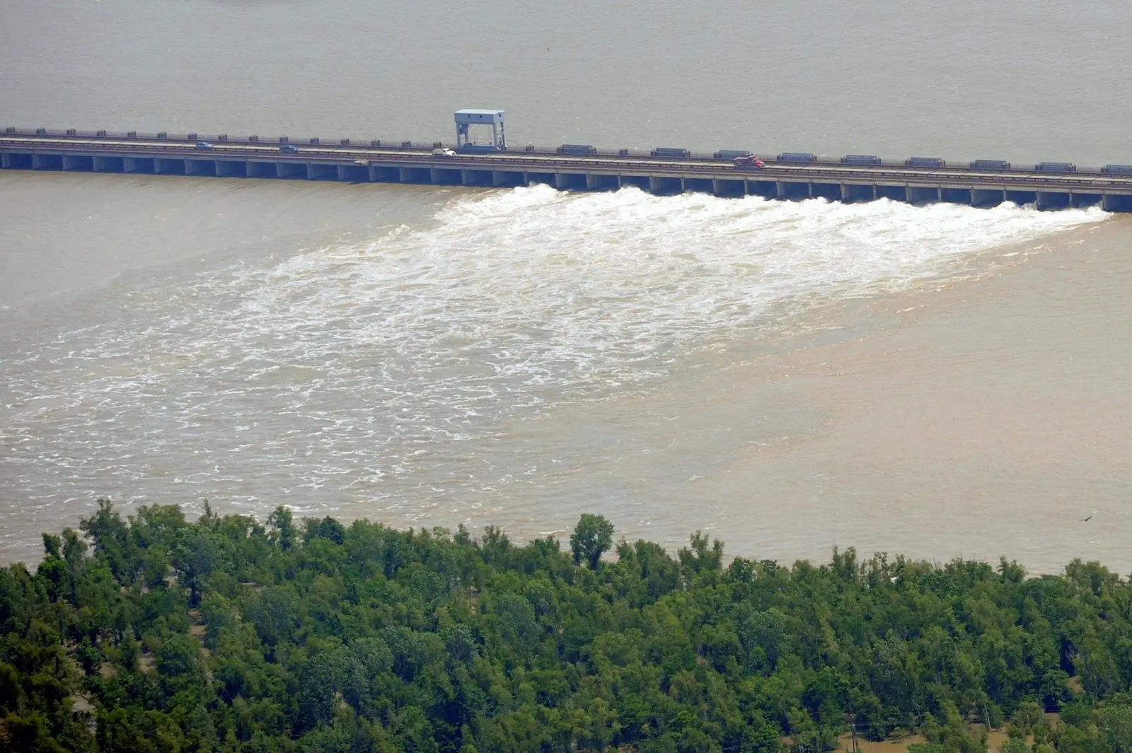
On the fourteenth of May, the Corps opened the Morganza Floodway, for the first time since nineteen seventy three. Two gates first, then more, until seventeen of the one hundred and twenty five stood open. At its peak, on the eighteenth of May, the floodway carried about one hundred and eighty two thousand cubic feet per second into the basin, about five thousand cubic metres a second.
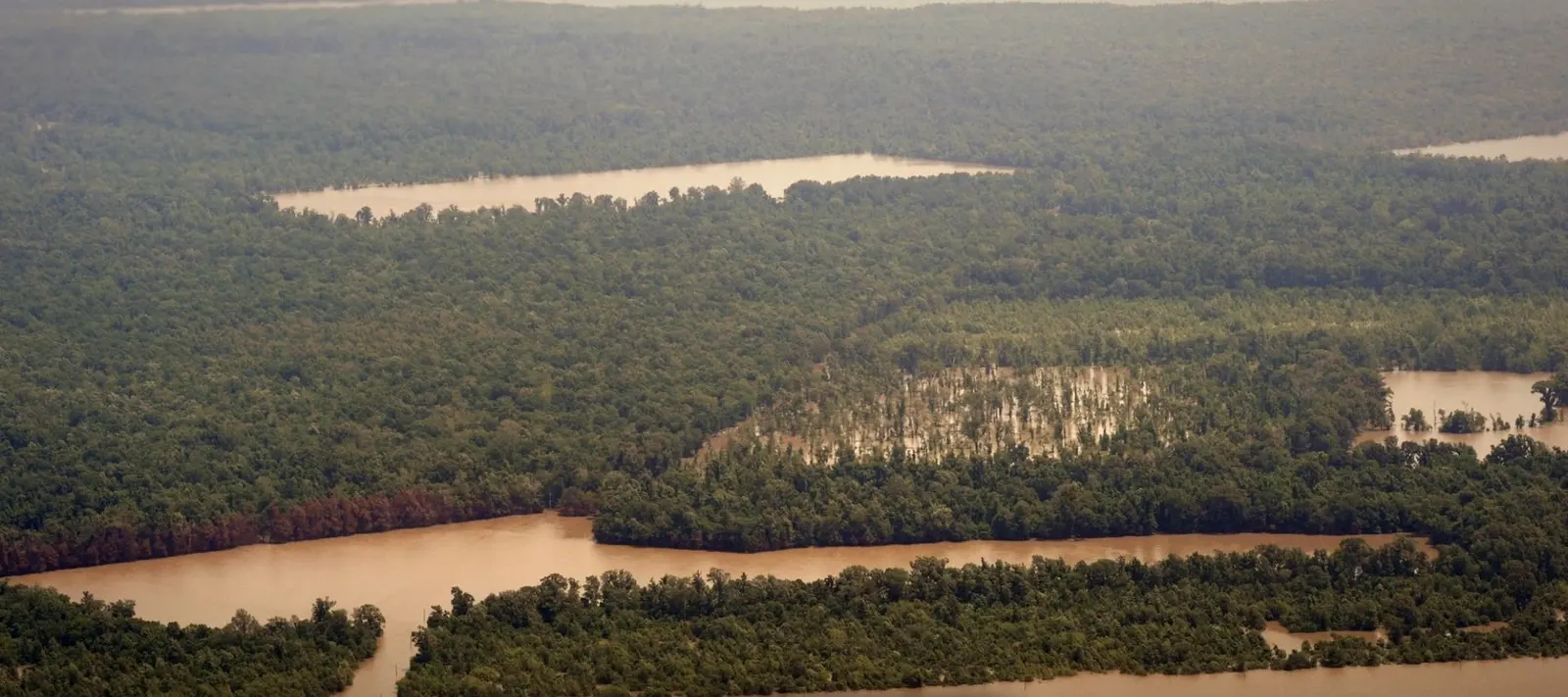
Downstream at Simmesport, the Atchafalaya's daily flow reached six hundred and ninety four thousand cubic feet per second on the twenty third of May. From orbit, satellites tracked the flood water reaching the Gulf as plumes of sediment.
Morganza, 14 May to 9 June 2011
In the 2011 flood the Corps opened bays of the Morganza structure to send water down the floodway toward the Atchafalaya Basin. Step through the days.
0 of 125 gated openings open
The full record, 27 entries
- 14 May 20112 of 125 openings open, 2 opened that day21,000 cubic feet per second through the structure.Corps of Engineers daily table
- 15 May 20119 of 125 openings open, 7 opened that day96,000 cubic feet per second through the structure.Corps of Engineers daily table
- 16 May 201115 of 125 openings open, 6 opened that day158,000 cubic feet per second through the structure.Corps of Engineers daily table
- 17 May 201116 of 125 openings open, 1 opened that day170,000 cubic feet per second through the structure.Corps of Engineers daily table
- 18 May 201117 of 125 openings open, 1 opened that day182,000 cubic feet per second through the structure.Corps of Engineers daily table
- 19 May 201117 of 125 openings open179,000 cubic feet per second through the structure.Corps of Engineers daily table
- 20 May 201117 of 125 openings open179,000 cubic feet per second through the structure.Corps of Engineers daily table
- 21 May 201117 of 125 openings open178,000 cubic feet per second through the structure.Corps of Engineers daily table
- 22 May 201117 of 125 openings open175,000 cubic feet per second through the structure.Corps of Engineers daily table
- 23 May 201117 of 125 openings open173,000 cubic feet per second through the structure.Corps of Engineers daily table
- 24 May 201116 of 125 openings open, 1 closed that day160,000 cubic feet per second through the structure.Corps of Engineers daily table
- 25 May 201114 of 125 openings open, 2 closed that day140,000 cubic feet per second through the structure.Corps of Engineers daily table
- 26 May 201112 of 125 openings open, 2 closed that day121,000 cubic feet per second through the structure.Corps of Engineers daily table
- 27 May 201112 of 125 openings open120,000 cubic feet per second through the structure.Corps of Engineers daily table
- 28 May 201112 of 125 openings open119,000 cubic feet per second through the structure.Corps of Engineers daily table
- 29 May 201111 of 125 openings open, 1 closed that day109,000 cubic feet per second through the structure.Corps of Engineers daily table
- 30 May 201110 of 125 openings open, 1 closed that day98,000 cubic feet per second through the structure.Corps of Engineers daily table
- 31 May 201110 of 125 openings open97,000 cubic feet per second through the structure.Corps of Engineers daily table
- 1 June 20119 of 125 openings open, 1 closed that day86,000 cubic feet per second through the structure.Corps of Engineers daily table
- 2 June 20118 of 125 openings open, 1 closed that day76,000 cubic feet per second through the structure.Corps of Engineers daily table
- 3 June 20117 of 125 openings open, 1 closed that day65,000 cubic feet per second through the structure.Corps of Engineers daily table
- 4 June 20117 of 125 openings open64,000 cubic feet per second through the structure.Corps of Engineers daily table
- 5 June 20117 of 125 openings open61,000 cubic feet per second through the structure.Corps of Engineers daily table
- 6 June 20115 of 125 openings open, 2 closed that day41,000 cubic feet per second through the structure.Corps of Engineers daily table
- 7 June 20113 of 125 openings open, 2 closed that day24,000 cubic feet per second through the structure.Corps of Engineers daily table
- 8 June 20112 of 125 openings open, 1 closed that day15,400 cubic feet per second through the structure.Corps of Engineers daily table
- 9 June 20111 of 125 openings open, 1 closed that day7,400 cubic feet per second through the structure.Corps of Engineers daily table
New land in the bay, and the split held at Old River
At the mouth of the Atchafalaya, the river is building land. Ten miles, or sixteen kilometres, west of the river's main mouth, a channel dug in the middle of the last century, the Wax Lake Outlet, carries part of the flow to the bay. The Wax Lake Delta at its end first rose above the water after the nineteen seventy three flood. Satellite images since nineteen eighty four show it, and the Atchafalaya Delta beside it, growing into the bay. In twenty fourteen, the USGS called them two of the few places on the Louisiana coast with some measure of land gain.
“When river flows at the Red River Landing are predicted to reach 1.5 million cfs and rising, the Corps considers opening the Morganza Floodway.”
Corps, New Orleans District, Morganza
Along the present channel, the map shows what has grown up beside it. Baton Rouge. New Orleans. In two thousand nine, the Corps listed what stands along both banks: refineries, petrochemical plants, grain elevators and power stations, most of them dependent on fresh water. River traffic from the nation's heartland runs to the ports of Baton Rouge and New Orleans.
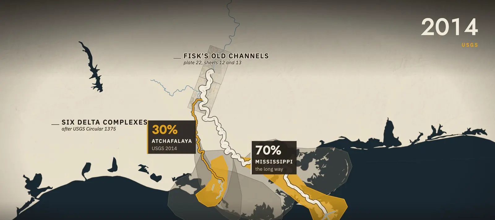
The whole history sits on one map. Six deltas along three hundred kilometres of coast. The old channels Fisk drew in the valley. And a route to the Gulf less than half as long as the one the river uses now. In twenty fourteen, the U.S. Geological Survey reported that about thirty percent of the flow goes down the Atchafalaya, the share set in the plan Congress authorized in nineteen fifty four. The rest is held to the long way, by the gates at Old River.
Fact check and sources
Harold N. Fisk, in his 1952 report for the Mississippi River Commission:
“A critical stage is to be expected at some time before 50 per cent of the flow is diverted. Following this critical stage, closure of the Mississippi River below Old River will be rapid and diversion will be uncontrollable.”
Fisk, Geological investigation of the Atchafalaya Basin and the problem of Mississippi River diversion, 1952, paras. 216 and 217
Checked against the record
- 142 against 315 Two ways to the same sea.
The Atchafalaya offered the Mississippi a shorter outlet to the Gulf of Mexico
Corps 2009, p. 5 - 5 to 25 per cent The share that went the short way, 1900 to 1950.
Discharge through the distributary has increased, since 1900, from 5 per cent to 25 per cent of the total annual flow of the Mississippi
Fisk 1952, para. 49 - 3 Sep 1954 The control project authorized.
On September 3, 1954, Congress authorized the Old River Control Project.
Corps 2009, p. 8 - 1.5 million cfs When Morganza is considered.
When river flows at the Red River Landing are predicted to reach 1.5 million cfs and rising, the Corps considers opening the Morganza Floodway.
Corps, New Orleans District, Morganza
Sources
- US Army Corps of Engineers, New Orleans District, Old River Control, Jan 2009
- Mississippi River Commission, Old River Control, archived 19 Oct 2016
- H. N. Fisk, Alluvial Valley of the Lower Mississippi River, Mississippi River Commission, 1 Dec 1944, plate 22
- H. N. Fisk, Atchafalaya Basin and the Problem of Mississippi River Diversion, Mississippi River Commission, Apr 1952
- USACE New Orleans District, Morganza Floodway Overview, archived 18 Oct 2016
- USGS Circular 1375, 2012 (deltas after Blum and Roberts, 2009)
- USGS Professional Paper 1798-L, 2014
- USGS, Louisiana Coastal Wetlands: A Resource At Risk
- USGS NWIS 07381490, Atchafalaya at Simmesport, daily, 2009 to 2025
- USGS NWIS 07289000, Mississippi at Vicksburg, peaks
- USGS National Hydrography Dataset
- USGS GNIS place names
- NASA Earth Observatory, Morganza Spillway Opens in Louisiana, 17 May 2011
- NASA Earth Observatory, Taming the Mississippi River
- NASA Earth Observatory, Growing Deltas in Atchafalaya Bay
- Terrain: USGS 3DEP via AWS Terrain Tiles. Map data: Natural Earth.
Pictures on this page
- Morganza spillway open, 20 May 2011, P. Kelley · U.S. Coast Guard via DVIDS, 1102976. US federal government work, public domain · Source
- Shreve's snagboat Archimedes, 1838 · National Archives, NAID 220305182. US federal government record, unrestricted use · Source
- Morganza structure under construction, 1952 · USACE New Orleans District, 8913-5. US federal government work, public domain · Source
- Morganza opening, 17 Apr 1973 · USACE New Orleans District, 13562-16. US federal government work, public domain · Source
- Old River from orbit, Feb 2014, Landsat 8 · NASA Earth Observatory, 85519. US federal government work (NASA, USGS Landsat) · Source
- Film stills, loops, maps and diagrams: from the Backstory Report film, drawn from the sources above.
Every archive picture in the film, with its rights (24)
- Old River elevation, 2011, R. Simmon · NASA Earth Observatory, 50824. US federal government work (NASA) · Record
- Mississippi delta from orbit, 2019, ISS crew · NASA JSC, ISS059-E-36323. US federal government work (NASA) · Record
- Mississippi at the Red River, 1774, W. Wilton · USACE Office of History, MRC 91. US federal government work, public domain · Record
- Shreve's snagboat Archimedes, 1838 · National Archives, NAID 220305182. US federal government record, unrestricted use · Record
- U.S. Snagboat No. 2, 1889, Harper's Weekly · USACE Office of History, 7291. Public domain (Corps statement; published 1889) · Record
- Snagboat Benjamin Humphreys, 1908 · USACE Office of History, 645. US federal government work, public domain · Record
- MRC steamer Mississippi at Cairo, 1909 · USACE Office of History, 6643. US federal government work, public domain · Record
- Old River Lock gate, 2022, R. Labadens · USACE New Orleans via DVIDS, 7500734. US federal government work, public domain · Record
- Morganza structure under construction, 1952 · USACE New Orleans District, 8913-5. US federal government work, public domain · Record
- Atchafalaya flood area, 1973, J. Messina · National Archives, 412-DA-10352. US federal government record, unrestricted use · Record
- Morganza opening, 17 Apr 1973 · USACE New Orleans District, 13562-16. US federal government work, public domain · Record
- Morganza Floodway, 5 May 1973, Landsat · NASA Earth Observatory, 50605. US federal government work (NASA, USGS Landsat) · Record
- Lower Mississippi, Feb 2014, Landsat 8 · NASA Earth Observatory, 85519. US federal government work (NASA, USGS Landsat) · Record
- Atchafalaya Basin in flood, 2011, P. Kelley · U.S. Coast Guard via DVIDS, 1133458. US federal government work, public domain · Record
- Morganza from orbit, 15 May 2011, EO-1 · NASA Earth Observatory, 50623. US federal government work (NASA) · Record
- Morganza spillway open, 20 May 2011, P. Kelley · U.S. Coast Guard via DVIDS, 1102976. US federal government work, public domain · Record
- Sediment plumes, 17 May 2011, MODIS · NASA Earth Observatory, 51167. US federal government work (NASA, NOAA data) · Record
- Atchafalaya Bay, 1984, Landsat 5 · NASA Earth Observatory, 85261. US federal government work (NASA, USGS Landsat) · Record
- Atchafalaya Bay, 2014, Landsat 8 · NASA Earth Observatory, 85261. US federal government work (NASA, USGS Landsat) · Record
- Baton Rouge from orbit, 2024, ISS crew · NASA JSC, ISS072-E-33734. US federal government work (NASA) · Record
- Shreve's snagboat, side view, 1838 · National Archives, NAID 404582133. US federal government record, unrestricted use · Record
- Old River Lock dewatered, 2022, R. Labadens · USACE New Orleans via DVIDS, 7500732. US federal government work, public domain · Record
- Morganza, 20 bays open, 22 May 1973 · USACE Office of History, 13750-3. US federal government work, public domain · Record
- Old River from orbit, Feb 2014, Landsat 8 · NASA Earth Observatory, 85519. US federal government work (NASA, USGS Landsat) · Record
Corrections. None to this case so far. Every correction is dated on the sources and corrections page.
Related cases
All cases
Why a Quarter of the Netherlands Is Below Sea Level
About a quarter of the country lies below sea level, and much of it sank because people drained it.
Both Engines Fail Over New York
Geese took both engines at 2,818 feet. Three and a half minutes later the crew put the airliner on the river.
Why You Couldn't Take One Train Across Australia
The colonies laid three widths of track. Until 1962 no passenger train ran through from Sydney to Melbourne.